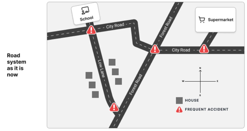
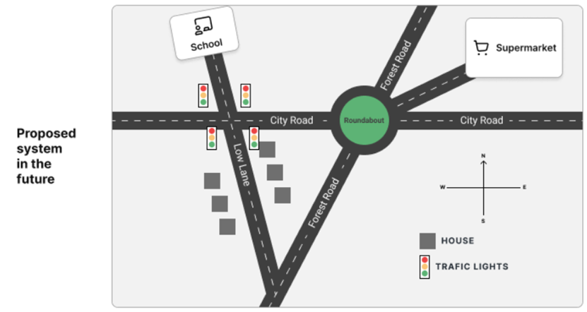
The maps show a road system as it is now and the proposed changes in future to reduce the number of accidents.
39/49
The maps show a road system as it is now and the proposed changes in future to reduce the number of accidents.
Hướng dẫn giải:
Gợi ý 1:
The two maps illustrate the current road layout and the proposed future modifications designed to enhance traffic safety and reduce accidents. Overall, the area is set to undergo significant infrastructural changes, notably the straightening of roads, the installation of traffic lights, and the construction of a roundabout to replace accident-prone junctions.
Currently, the road network features several hazardous intersections marked by frequent accidents. City Road runs horizontally with sharp bends, intersecting with Low Lane near a school and with Forest Road further to the east near a supermarket. Another major accident hotspot is located at the southern junction where Low Lane merges into Forest Road, surrounded by a residential cluster of six houses.
In the proposed future plan, City Road will be straightened into a single, direct horizontal thoroughfare. The dangerous junction near the school on Low Lane will be regulated by the installation of multiple sets of traffic lights. Furthermore, the complex intersection where City Road meets Forest Road will be replaced by a large roundabout, which will also connect to a relocated entrance for the supermarket. Finally, the southern intersection of Low Lane and Forest Road will be smoothed out, eliminating the previous sharp convergence point entirely.
(Hai bản đồ minh họa bố cục đường bộ hiện tại và các sửa đổi trong tương lai được đề xuất nhằm nâng cao an toàn giao thông và giảm thiểu tai nạn. Nhìn chung, khu vực này sẽ trải qua những thay đổi cơ sở hạ tầng đáng kể, đáng chú ý là việc nắn thẳng đường, lắp đặt đèn giao thông và xây dựng một vòng xuyến để thay thế các nút giao dễ xảy ra tai nạn. Hiện tại, mạng lưới đường bộ có một số giao lộ nguy hiểm được đánh dấu bằng các vụ tai nạn thường xuyên. Đường City Road chạy theo chiều ngang với các khúc cua gấp, giao với Low Lane gần một trường học và với Forest Road xa hơn về phía đông gần một siêu thị. Một điểm nóng tai nạn lớn khác nằm ở giao lộ phía nam nơi Low Lane hòa vào Forest Road, được bao quanh bởi một cụm dân cư gồm sáu ngôi nhà. Trong kế hoạch tương lai được đề xuất, đường City Road sẽ được nắn thẳng thành một trục đường ngang duy nhất, trực tiếp. Giao lộ nguy hiểm gần trường học trên Low Lane sẽ được quản lý bằng việc lắp đặt nhiều bộ đèn giao thông. Hơn nữa, nút giao phức tạp nơi City Road gặp Forest Road sẽ được thay thế bằng một vòng xuyến lớn, nơi cũng sẽ kết nối với lối vào được di dời cho siêu thị. Cuối cùng, giao lộ phía nam của Low Lane và Forest Road sẽ được làm phẳng, loại bỏ hoàn toàn điểm hội tụ sắc nhọn trước đó.)
Gợi ý 2:
The provided diagrams depict a local road system in its current state alongside planned future alterations aimed at minimizing vehicle accidents. In general, the future layout transitions from a winding network with multiple high-risk collision zones into a streamlined system equipped with modern traffic controls and geometric improvements.
At present, the area experiences frequent accidents across four primary locations: the intersection of City Road and Low Lane by the school, the jagged junction between City Road and Forest Road, the eastern crossing near the supermarket, and the southern merging point of Low Lane and Forest Road. These risks are exacerbated by angled turns and unmanaged intersections near the residential housing block.
Under the future proposals, safety is prioritized through structural upgrades. Traffic lights will be systematically installed around the school zone and City Road crossings to control vehicle flow. Additionally, the awkward bends on City Road will be removed in favor of a straight alignment, and a roundabout will be established at the main intersection with Forest Road to streamline traffic moving toward the supermarket. These comprehensive measures aim to systematically eradicate the current accident blackspots.
(Các sơ đồ được cung cấp mô tả hệ thống đường địa phương ở trạng thái hiện tại bên cạnh các thay đổi trong tương lai được lên kế hoạch nhằm giảm thiểu tai nạn xe cộ. Nhìn chung, bố cục trong tương lai chuyển đổi từ một mạng lưới quanh co với nhiều khu vực va chạm rủi ro cao thành một hệ thống được hợp lý hóa được trang bị các biện pháp kiểm soát giao thông hiện đại và cải tiến hình học. Hiện tại, khu vực này thường xuyên xảy ra tai nạn ở bốn địa điểm chính: giao lộ City Road và Low Lane cạnh trường học, nút giao gập ghềnh giữa City Road và Forest Road, lối qua đường phía đông gần siêu thị và điểm nhập làn phía nam của Low Lane và Forest Road. Những rủi ro này càng trầm trọng hơn bởi các khúc cua nghiêng và các giao lộ không có người quản lý gần khối nhà ở dân cư. Theo các đề xuất trong tương lai, sự an toàn được ưu tiên thông qua việc nâng cấp cấu trúc. Đèn giao thông sẽ được lắp đặt có hệ thống xung quanh khu vực trường học và các điểm giao cắt City Road để kiểm soát dòng xe. Ngoài ra, các khúc cua khó xử trên City Road sẽ được loại bỏ để ủng hộ sự liên kết thẳng, và một vòng xuyến sẽ được thiết lập tại giao lộ chính với Forest Road để hợp lý hóa giao thông di chuyển về phía siêu thị. Các biện pháp toàn diện này nhằm mục đích xóa bỏ một cách có hệ thống các điểm đen tai nạn hiện tại.)