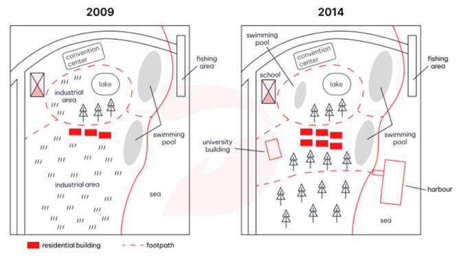
The map below shows the changes that have taken place at the waterfront area of a town called Darwin between 2009 and 2014.
3/24
The map below shows the changes that have taken place at the waterfront area of a town called Darwin between 2009 and 2014.
Hướng dẫn giải:
Gợi ý 1:
The maps illustrate the developments that occurred in the waterfront area of Darwin between 2009 and 2014. Overall, the area was significantly transformed, with industrial zones replaced by educational and recreational facilities, indicating a shift toward community and leisure use.
In 2009, the waterfront area featured two industrial zones—one near the lake and another in the southern part of the map. A convention center was located in the north, while a fishing area and a swimming pool were situated along the coastline. Several residential buildings stood near the center, surrounded by trees and connected by a footpath.
By 2014, the industrial areas had been completely removed. In their place, a school was built in the northwest and a university building appeared in the southwest. The number of swimming pools increased to two, one near the top and another near the center-right. A new harbour was also constructed along the coast, replacing part of the seaside area. The convention center and fishing area remained unchanged, while the residential buildings continued to occupy the central part of the map.
In summary, Darwin’s waterfront area underwent major redevelopment between 2009 and 2014, with industrial facilities replaced by educational institutions and leisure amenities, creating a more community-oriented environment.
(Hai bản đồ minh họa sự thay đổi của khu vực ven biển Darwin từ năm 2009 đến năm 2014. Nhìn chung, khu vực này đã được cải tạo đáng kể, với các khu công nghiệp được thay thế bằng cơ sở giáo dục và giải trí, cho thấy xu hướng phát triển hướng tới cộng đồng và nghỉ dưỡng.
Năm 2009, khu vực ven biển có hai khu công nghiệp—một gần hồ và một ở phía nam. Trung tâm hội nghị nằm ở phía bắc, trong khi khu câu cá và hồ bơi nằm dọc theo bờ biển. Một số tòa nhà dân cư nằm ở trung tâm, bao quanh bởi cây cối và được nối bằng lối đi bộ.
Đến năm 2014, các khu công nghiệp đã bị loại bỏ hoàn toàn. Thay vào đó, một trường học được xây ở phía tây bắc và một tòa nhà đại học xuất hiện ở phía tây nam. Số lượng hồ bơi tăng lên hai, một ở phía trên và một ở giữa bên phải. Một cảng mới cũng được xây dựng dọc bờ biển, thay thế một phần khu vực ven biển. Trung tâm hội nghị và khu câu cá vẫn giữ nguyên vị trí, trong khi các tòa nhà dân cư vẫn nằm ở trung tâm bản đồ.
Tóm lại, khu vực ven biển Darwin đã được tái phát triển mạnh mẽ từ năm 2009 đến 2014, với các cơ sở công nghiệp được thay thế bằng trường học và khu giải trí, tạo nên môi trường sống hướng tới cộng đồng hơn.)
Gợi ý 2:
The two maps compare the waterfront area of Darwin in 2009 and 2014. It is clear that the region experienced extensive modernization, with industrial zones converted into educational and recreational spaces.
In 2009, the area contained two industrial zones, one near the lake and another in the southern part. The convention center was located in the north, and a fishing area and swimming pool were positioned along the coast. Residential buildings occupied the central area, surrounded by trees and connected by a footpath.
By 2014, the industrial zones had disappeared. A school was added near the top left, and a university building was constructed in the southwest. The number of swimming pools doubled, and a new harbour was built along the sea. The convention center and fishing area remained in their original positions, while the residential buildings continued to dominate the central part of the map.
Overall, the waterfront area of Darwin was transformed from an industrial zone into a more educational and recreational district, reflecting urban development focused on community and leisure.
(Hai bản đồ so sánh khu vực ven biển Darwin vào năm 2009 và 2014. Rõ ràng rằng khu vực này đã trải qua quá trình hiện đại hóa mạnh mẽ, khi các khu công nghiệp được chuyển đổi thành khu giáo dục và giải trí.
Năm 2009, khu vực này có hai khu công nghiệp, một gần hồ và một ở phía nam. Trung tâm hội nghị nằm ở phía bắc, và khu câu cá cùng hồ bơi nằm dọc theo bờ biển. Các tòa nhà dân cư chiếm khu vực trung tâm, được bao quanh bởi cây cối và nối bằng lối đi bộ.
Đến năm 2014, các khu công nghiệp đã biến mất. Một trường học được thêm vào phía tây bắc, và một tòa nhà đại học được xây ở phía tây nam. Số lượng hồ bơi tăng gấp đôi, và một cảng mới được xây dựng dọc theo bờ biển. Trung tâm hội nghị và khu câu cá vẫn giữ nguyên vị trí, trong khi các tòa nhà dân cư vẫn là khu vực trung tâm.
Nhìn chung, khu vực ven biển Darwin đã được chuyển đổi từ khu công nghiệp thành khu giáo dục và giải trí, phản ánh sự phát triển đô thị hướng tới cộng đồng và nghỉ dưỡng.)